Register-Guard
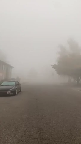
Smoke and fog Eugene
Example of poor air quality in Lane County, Oregon, when smoke and fog collide on Sunday, Sept. 13, 2020/
The National Weather Service in Portland issued advisories in Lane County for dense fog and smoke.
The combination of the smoke and fog limits visibility to less than one mile, with visibility from 0 to a half mile at times, leading to hazardous driving conditions and poor air quality.
Motorists, if they have to be on the road, should be prepared to stop suddenly and watch for bikers and pedestrians, who should make themselves visible with reflective clothing. If driving, slow down, use your headlights (but not your brights), and leave plenty of distance ahead of you.
The Lane Regional Air Protection Agency's Air Quality Index at 8 a.m. was hazardous around the county, with Eugene at 421 AQI, Cottage Grove at 473, and Oakridge at 408. It's the third consecutive day Eugene has hit 400 or higher on the index, which tops out at 500.
Official recommend limiting outdoor time and people with respiratory illnesses should remain indoors to avoid inhaling smoke.
Some Holiday Farm Fire evacuation zones downgraded
Several evacuation zones have been downgraded, Lane County announced at 6 p.m. Saturday.
Officals are emphasizing that the areas downgraded to Level 2 ("be set"), from Level 3 ("go now"), reflect that fire danger has only subsided enough to allow residents access so they can make additional preparations for their homes, livestock or other animals.
Residents should expect that if fire behavior increases, those areas may return to Level 3 and residents must be able to leave again at a moment’s notice.
The evacuation level for many residents in the Mohawk Valley has been downgraded from a Level 3 ("go now") to a Level 2 ("be set"). The downgraded area includes the Mohawk Valley to the Linn County line with two exceptions:
The area west of Marcola Road south of the intersection with Hill Road is being downgraded from a Level 2 ("be set") to a Level 1 ("be ready").
The area east of the Mohawk River from Wendling Road to the county line remains at Level 3 ("go now") , including Wending Road, Paschelke Road, Hileman Road, Bunker Hill Road and Mohawk River Road and their connecting roads.
The evacuation level for residents along Highway 126 from Thurston Road to the intersection of Cedar Flat Road, including Cedar Flat Road and Camp Creek Road west of Upper Camp Creek Road, is being downgraded from a Level 3 ("go now") to a Level 2 ("be set").
Level 2 means there is significant danger to that area and residents should either voluntarily relocate to a shelter or with family/friends outside of the affected area and be ready to evacuate at a moment's notice. Emergency responders may not have time to provide you with additional notice if danger increases.
Here is a roundup of all Lane County evacuation notices as of 6 p.m. Saturday:
Level 3 "Go Now"
- Everyone from Walterville Elementary east to the McKenzie Ranger Station, including all roads to the north and south of the highway.
- East of the Mohawk River from Wendling Road to the county line, including Wending Road, Paschelke Road, Hileman Road, Bunker Hill Road and Mohawk River Road and their connecting roads.
"Level 3 means leave immediately! Do NOT take time to gather things. Go now! DO NOT delay leaving your property to gather any belongings or make efforts to protect your home. If you choose to ignore this notice, public safety personnel may not be available to assist you further."
Level 2 "Be Set"
-
Residents from the McKenzie Ranger Station to the junction of Highway 126 and Highway 20 (Santiam Junction).
-
The entire Mohawk Valley to the Linn County line (except the area west of Marcola Road south of intersection with Hill Road is Level 1). Note: Area east of the Mohawk River from Wendling Road to the county line remains Level 3, including Wending Road, Paschelke Road, Hileman Road, Bunker Hill Road and Mohawk River Road and their connecting roads.
-
Highway 126 to intersection with Cedar Flat Road, including Cedar Flat Road, along with Camp Creek Road west of Upper Camp Creek Road.
Level 2 means being prepared to leave at a moment's notice. It indicates there is significant danger to your area and residents should either voluntarily relocate to a shelter or with family/friends outside of the affected area.
Level 1 "Be Ready"
- The Mohawk Valley west of Marcola Road south of the intersection with Hill Road.
- The Fall Creek, Winberry, and Lowell areas north from Hills Creek to Signal Point Boat Ramp.
- All residents from Highway 126 to Bob Straub to Jasper Road east to Thurston Road where it intersects with Highway 126 north to the McKenzie River.
Level 1 means be aware of the danger that exists in your area and prepare for possible evacuation.
How to find out if you're in an evacuation zone
With multiple evacuation notices in effect for the McKenzie River corridor area, Lane County created a Fire Zone Evacuation Address Search to quickly find out whether your address is in the evacuation zone.
Go to lcmaps.lanecounty.org/EvacuationSearch2020/index.html to enter in your address to find out.
Residents who are affected by the Holiday Farm Fire who have inquiries may call Lane County’s non-emergency call center at 541-682-3977 between 7 a.m. and 10 p.m. After-hours calls will be transferred to the Sheriff’s Office non-emergency phone line. People also can go to lanecounty.org/mckenziefire
If you are under an evacuation notice, please comply with requests made for Level 1 (Be Ready), Level 2 (Be Set) and Level 3 (Go Now).
Lane County has a temporary evacuation point at Silke Field, 908 N. 10th Ave. in Springfield for those who were able to evacuate to the west.
Holiday Farm Fire search and rescue operations begin
Search and rescue operations in areas affected by the Holiday Farm Fire began Saturday, starting around Rainbow and moving west toward Blue River.
The progress in stalling the fire, including the assembly of more manpower, let those search operations begin, Office of the State Fire Marshal spokesman Lt. Damon Simmons said Saturday morning. As of Saturday afternoon, one person is known to have died.
The fire burning in the McKenzie Valley around Highway 126 threatens 17,732 structures, the Oregon Department of Forestry reported Saturday.
Simmons said firefighters expected Saturday's weather to be much like the day before: smoky, cool and beneficial for suppression efforts. He said firefighters expected terrain-driven fire Saturday, meaning it would burn uphill where firefighters can create breaks.
Simmons said firefighters would be working in the northwest, southern and northern portions of the fire Saturday, attempting to strengthen fire lines. Once firefighters are more confident those lines will hold, he said, evacuation levels may be lowered.
"A lot of fire break creation today. A lot of line creation expected today," Simmons said Saturday morning. "We may not see the extent of the line that is created today reflected in our perimeter numbers, in our amount of containment, because they need that line to be tested."
Firefighters completed a successful burnout operation in the southwestern corner of the fire to establish a solid control line, the Oregon Department of Forestry reported in its daily update Saturday. The news release said crews continue to mop up and scout new locations for control lines.
The fire was 0% contained as of Saturday afternoon, according to the Oregon Department of Forestry.
More: Holiday Farm Fire search and rescue operations begin
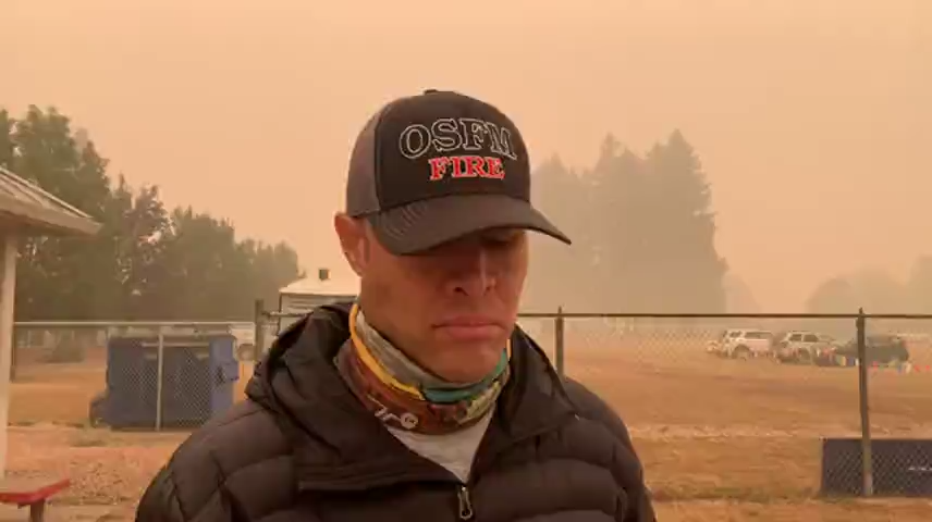
Watch: OSFM offers update on the Holiday Farm Fire
OSFM Spokesman Damon Simmons offers update on the Holiday Farm Fire.
500,000 are told to evacuate or prepare to do so
Hundreds of firefighters battled two large wildfires Friday that threatened to merge near the most populated part of Oregon, including the suburbs of Portland, and the governor said dozens of people are missing in other parts of the state.
The state’s emergency management director, Andrew Phelps, said thousands of structures have been destroyed.
Gov. Kate Brown said more than 40,000 Oregonians have been evacuated and about 500,000 are in different levels of evacuation zones, either having been told to leave or to prepare to do so. She was dialing back on a statement Thursday by the state Office of Emergency Management that said a half-million people had been ordered to evacuate statewide.
— USA TODAY
Donations: Best way to help is to contribute financial donations
On Saturday, based on the overwhelming community support of goods and supplies, the organizers asked that the community pause from giving any more donations, and consider giving monetarily.
Given the high volume of in-kind donations already received, both the Springfield Silke Field and the Eugene Roosevelt Boulevard donation sites are no longer accepting donations. The latter site, managed by St. Vincent de Paul, United Way of Lane County and the Lane County Emergency Operations Center, was set up just Friday, and has already received an overwhelming outpouring of support of goods and supplies for victims of the Holiday Farm Fire.
At this point, the most helpful way for community members to contribute is to make a financial donations to United Way’s Wildfire Response Fund: http://egiving.unitedwaylane.org/wildfires.
If specific donated goods are needed for fire victims in coming weeks, an announcement of needed items and a donation site will be shared at that time.
St. Vincent de Paul, United Way of Lane County and the Lane County Emergency Operations Center are partnering with the grassroots organizers of the donation center to support the center. St. Vincent de Paul is managing the donation location and overall process.
Escaping the Holiday Farm Fire, many left with just the clothes on their backs
One step ahead of the fire, bringing little more than the kids, the pets and the clothes on their backs, many arrived in Springfield and Eugene safe but unsure, alive but lost.
The Holiday Farm Fire is estimated have burned about 161,800 acres as of Saturday morning, destroying the town of Blue River and damaging nearby communities. At least one person was killed, but search and rescue operations only truly began Saturday.
The fire began Monday night, and with it came the warnings to be ready to leave or to go now. Those who fled say their exits often were sudden, and not everyone received alerts on their phones.
In choking smoke, under falling ash, driving past burning hillsides, evacuees fled beyond the fire's reach where they filled nearby relatives' homes, emergency shelters and hotel rooms. Whether they knew it yet or not, the things they had with them on arrival were now all they had — bare essentials and priceless keepsakes alike were left behind.
There was comfort in the kindness of strangers. There was relief in donations, great in their quantity but still not enough. There was joy in reunion with friends and neighbors.
But even days after leaving, many still do not know if their homes are standing. News that did filter back to them was often bad. There is little to do but take it day by day.
More: Escaping the Holiday Farm Fire, many left with just the clothes on their backs

Oregon wildfire: 'I knew I'd never see anything in that house again.'
Lindsie and Brittany Cline from Leaburg at an evacuation center at Springfield High after their families fled the flames of the Holiday Farm Fire.
Hazardous air quality cancels several weekend events
From parks to outdoor events, here's a list of closures because of the unhealthy, smoky air quality: www.registerguard.com/story/news/2020/09/11/holiday-farm-fire-closures-cancellations-lane-county/3473074001/
Gov. Brown: Dozens reported missing during Oregon wildfires
Dozens of people have been reported missing in the Oregon wildfires, Gov. Kate Brown confirmed Friday.
Oregon State Police are reporting dozens of cases, specifically in Lane, Jackson and Marion counties.
Oregon's Office of Emergency Management Director Andrew Phelps said thousands of structures have been destroyed in the catastrophic fires and officials were preparing for a "mass fatality event."
Oregon's wildfires ballooned to more than 1 million acres Friday.
Officials with the Marion County Sheriff's Office said as of Friday, 10 people reported missing in connection to the wildfires have yet to be accounted for. The remains of four people have been found.
"At a time of great loss, the women and men of the Marion County Sheriff’s Office want to express their deepest condolences to those in our community who have lost loved ones and homes during these last few days,” Sheriff Joe Kast said in a statement.
Family members and officials confirmed that a 13-year-old boy and his 71-year-old grandmother died in the Beachie Creek Fire in Marion County.
Searchers also located two additional victims of the Beachie Creek Fire.
"Due to treacherous conditions, recovery efforts will be underway once a safe plan can be put into place," Griffith said. "Once the remains are identified, names will be released pending notification of next of kin."
One body was discovered in a residence in the Goodpasture Road area of Vida within the perimeter of the Holiday Farms Fire, according to the Lane County Sheriff's Office.
Two bodies were recovered in the Almeda Fire in southern Oregon. The Oregonian/OregonLive reported that 50 people remain unaccounted for in the aftermath of the fire.
Many have turned to Twitter and Facebook for help with finding their missing loved ones. A father's tweet to find his daughter and her boyfriend, who went missing while camping near McKenzie Bridge, collected more than 23,000 retweets.
The woman and her boyfriend were located Thursday and are now safe, according to the father's social media page.
Brown did not provide a hard number of how many people were reported missing and said the primary focus remained on saving lives.
Brown said she expects the initial number of reports to change.
"Right now, I know that Oregonians are very eager to seek information," Brown said. "As we get more information regarding missing persons and fatalities and structure damage, we will certainly provide that information, but it is going to take time."
— Whitney Woodworth, Salem Statesman Journal
Greenhill Humane Society providing emergency pet services
Greenhill Humane Society is working with local authorities to provide emergency services for Lane County pets. This includes emergency boarding for dogs, cats and other small animals in evacuation zones.
To coordinate emergency boarding, contact Greenhill 24 hours-a-day at 541-689-1503 or www.green-hill.org.
Pet food and supplies are also being distributed at the evacuation zone and are available for pickup from Greenhill Humane Society at 88530 Green Hill Road.
— Matthew Denis
Firefighters: Beachie Creek, Riverside fires may create their own weather
The biggest concern about the Riverside Fire and Beachie Creek Fire is that they could merge, Holly Krake, public information officer with the Riverside Fire, said Friday morning. The fires were about 1 air mile apart, but they could merge if fire growth continues.
The concern about those fires merging is rooted in smoke.
In general, if smoke plumes from two massive fires converge, it has the potential to create “plume dominated” fire behavior. This behavior is marked on the ground by down draft winds, erratic wind shifts and plunging humidity.
Essentially, the fire could have its own weather.
These conditions can limit the ability for firefighters to combat the blaze directly and puts any towns in the fire’s path at greater risk. Fuels in the Mt. Hood National Forest – where the fire is burning – are already at record dryness levels.
“You combine extremely dry fuels, erratic winds, a fire creating its own weather conditions, it can lead to some of those extreme fire behaviors that just aren’t safe,” Krake said.
On Thursday, the fire’s intensity led officials to pull back all firefighting and emergency personnel for about two hours.
Clackamas Fire called it a “tactical pause” to allow firefighters to reposition and evaluate conditions.
“We haven’t abandoned you & working hard to keep you safe,” they tweeted.
Krake said 178 personnel are currently battling the fire, with more expected to arrive over the weekend.
Air support is also available, but due to thick smoke few flights have been made since the fire started on Sept. 8.
— Connor Radnovich, Salem Statesman Journal
The Link LonkSeptember 13, 2020 at 08:04PM
https://ift.tt/3bTjgtC
Updates: Some Holiday Farm Fire evacuation zones downgraded; search and rescue operations begin - The Register-Guard
https://ift.tt/2QoXNjh
Holiday


No comments:
Post a Comment